Harbor Watch Intelligence
Real-Time Maritime Intelligence for Smarter Response and Safer Waters
HarborWatch provides local maritime agencies with exclusive access to real-time, captain-sourced incident reporting and intelligence specifically for their jurisdiction
By connecting verified captains directly to authorized agencies, HarborWatch delivers GPS-verified reports, supporting media, and structured incident data — helping teams respond faster, prioritize resources, and make more informed operational decisions.
Built in alignment with the Slow Is Pro mission, HarborWatch supports a safer, more accountable
maritime culture across the Caribbean and beyond.
Trusted by Captains, Marine Professionals, and Local Maritime Agencies.
A Complete Maritime Intelligence Ecosystem
HarborWatch creates a direct informational bridge between those on the water and those who protect it. Instead of
delayed calls, missing details, or fragmented reporting, agencies receive structured, real-time intelligence that improves
both immediate response and long-term prevention.
Together, we create a safer, more accountable marine environment—without overextending resources.
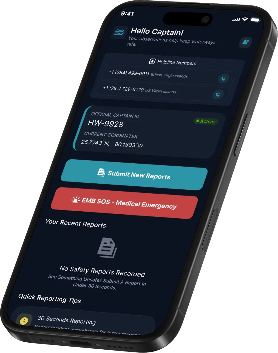
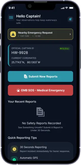
Real-Time Reporting
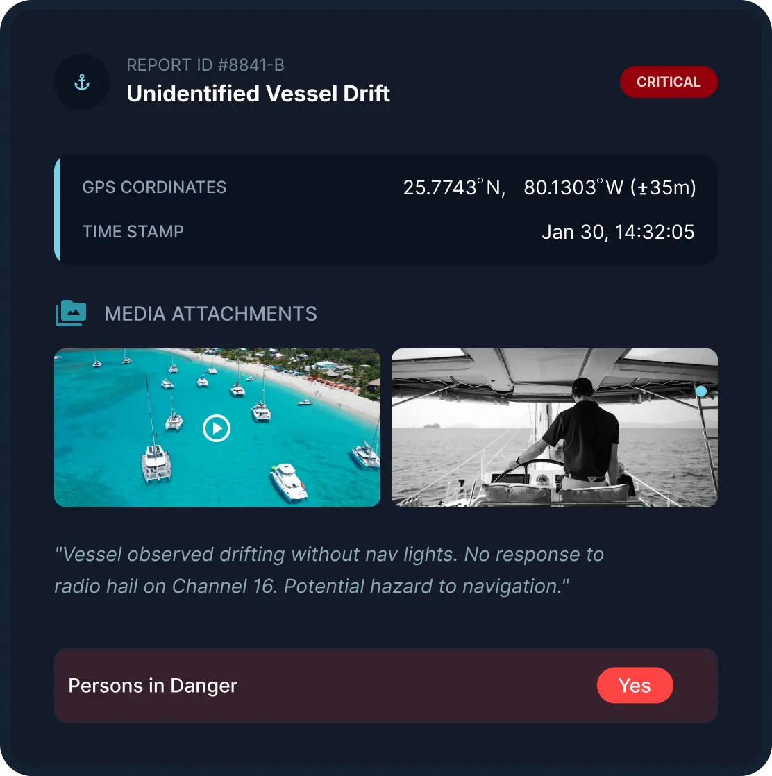
Receive incident reports directly from verified captains with GPS coordinates, media uploads, timestamps, and critical situational details.
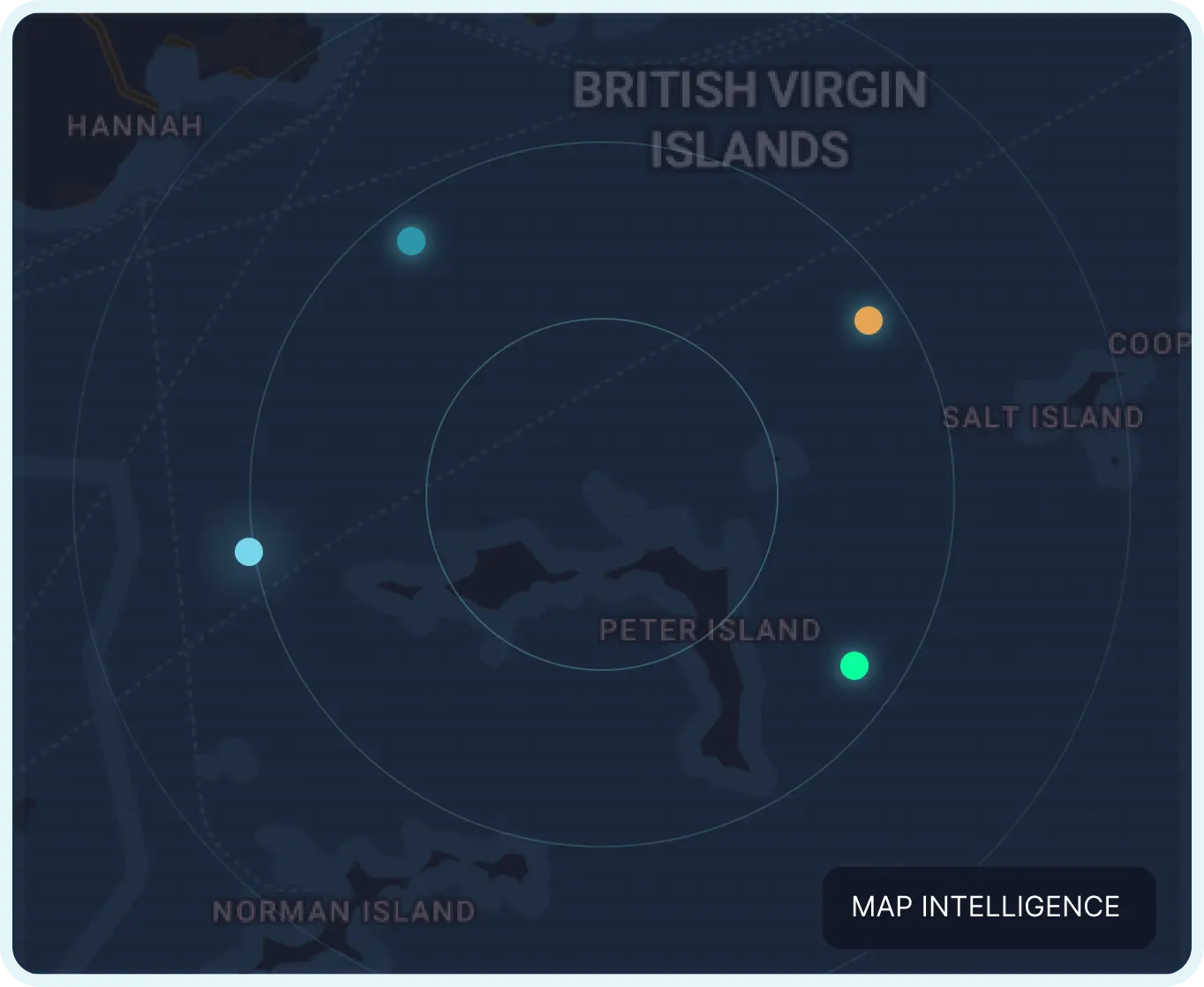
Live Map & Visual Intelligence
Identify high-risk zones, repeat incidents, navigational hazards, behavioral patterns and opportunities for prevention through live heat maps and incident history.
Advanced Filtering
Filter incident data by date range, location, and category to isolate trends, monitor activity patterns, and support targeted response strategies.
How Captains Power the
System
Captains serve as the first line of visibility on the water.
Through the HarborWatch app, verified captains can confidentially report unsafe behavior, navigational hazards, collisions, emergencies, environmental concerns, and urgent incidents in real time.
This helps enforce accountability on the water while giving agencies access to faster, more reliable field intelligence.
Precision Reporting
Report unsafe or reckless behavior, flag navigational hazards and environmental risks and submit incident reports with GPS and media evidence.
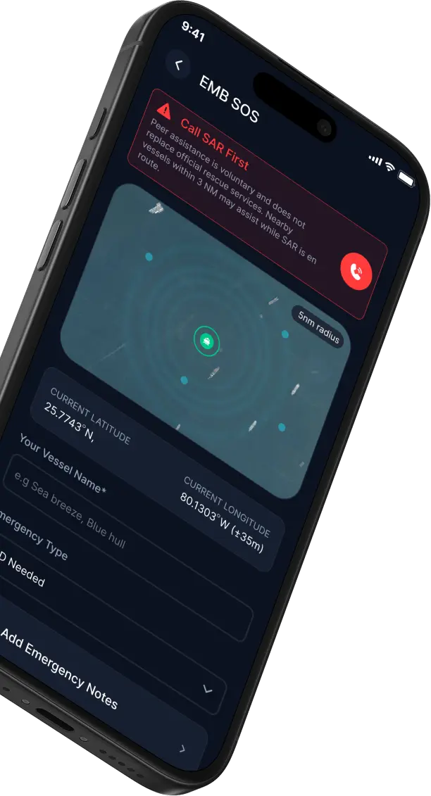
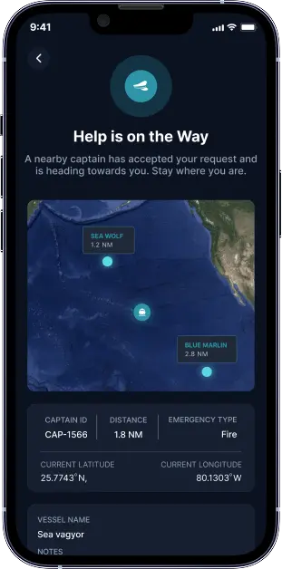
SOS Emergency Message Board
One-tap captain-to-captain assistance request to nearby vessels as Search and Rescue is in route.
Responsible Accountability
Confidential reporting tools significantly increase accountability and reduce reckless behavior while protecting professional relationships within the industry.
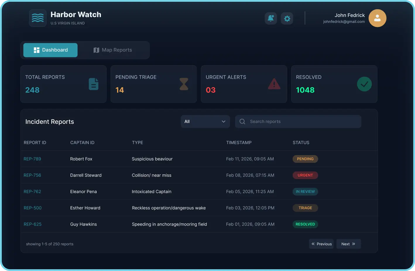
Monitoring Portal
Extend your reach without expanding your team. HarborWatch doesn’t just collect data—it helps maritime agencies act on it. Through
exportable, evidence-based reporting, HarborWatch enables your team to:
Operational Impact
Increase patrol frequency in identified hotspot areas
Support implementation of vessel speed restrictions where needed
Identify high-traffic and high-risk zones
Establish enforcement strategies for repeat offenders
Real-Time SOS. Immediate Support
When emergencies happen, response time determines outcomes. HarborWatch allows captains to
trigger immediate SOS alerts to other nearby captains, automatically sharing live GPS location, need
for first aid or lifesaving equipment, and emergency context. This is used after Search and Rescue is
called and in route.
Real-Time Alerts
Notify all nearby captains instantly during emergencies
Live Location
Automatically share your precise GPS coordinates
Fast Response
Get help from the closest available captains and first responders
Status Tracking
Track request progress from alert to assistance
Complete Reports.
Actionable
Intelligence.
Every report submitted through HarborWatch is designed to improve operational response and strengthen long-term maritime safety.
From collisions and speeding violations to reef damage, suspicious activity, grounding incidents, and environmental hazards— maritime agencies receive the data needed to respond effectively and reduce repeat incidents.
Better information creates better enforcement, accountability, and safer waters for everyone.
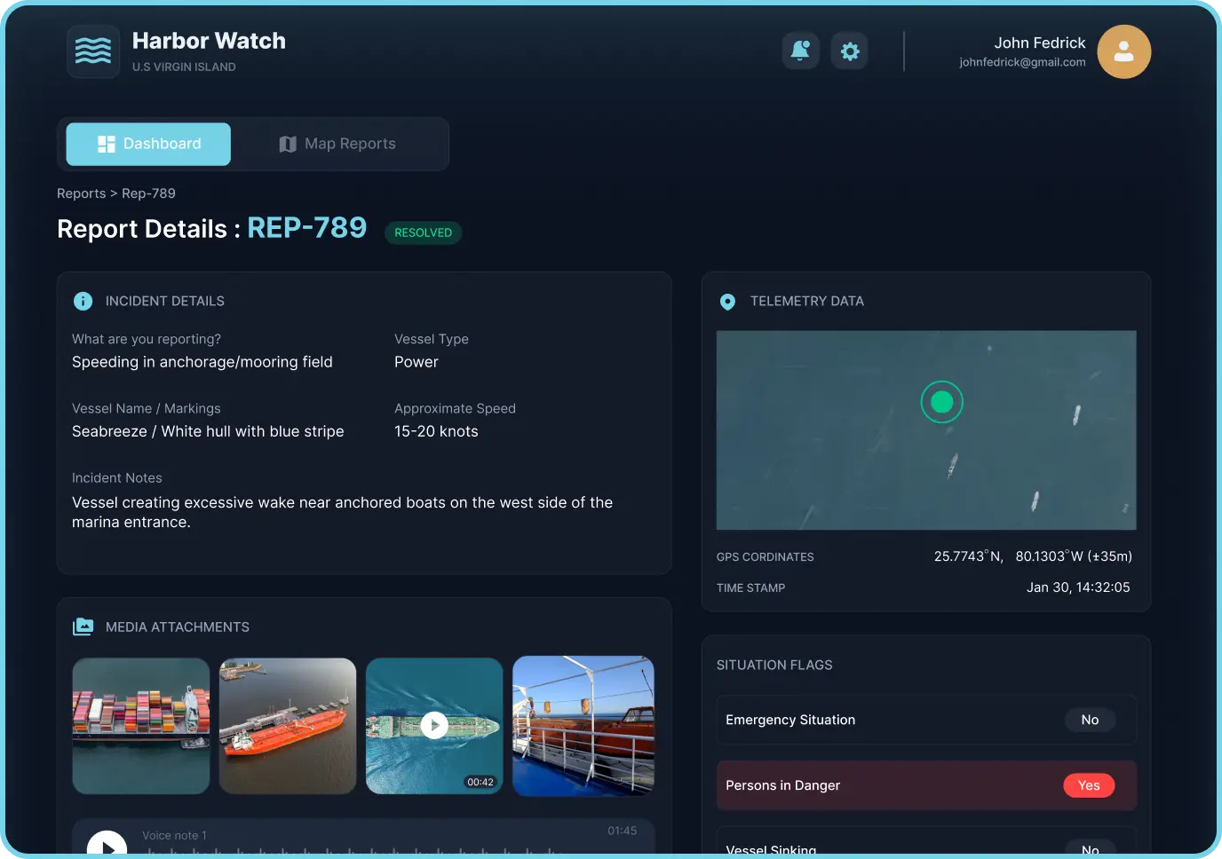
Real-Time Location
Hyper-accurate GPS coordinates with automatic zone classification
Visual Evidence
Compressed, high-fidelity imagery and video for visual evidence logs
Detailed Incident Data
Categorized metadata from hull status, persons in danger, or vessels sinking
Risk Indicators
Predictive threat levels based on historical local data
Environmental Conditions
Wind speed, swell height, and visibility metrics at time of report
Exclusive Access. Operational Value.
HarborWatch provides one complete platform for remote incident monitoring, response coordination, and maritime intelligence—without unnecessary complexity or hidden modules.
Your agency gains immediate access to structured reporting, live monitoring tools, and exportable safety data designed to improve operational efficiency across your waters.
In supporting HarborWatch, agencies also contribute to the broader Slow Is Pro mission of raising awareness, strengthening accountability, and creating lasting cultural change in the maritime industry.
Jurisdiction-specific incident reports
Access real-time and historical reports submitted by verified captains within your waters, giving your team stronger visibility into recurring risks, unsafe behavior, and emerging incidents.
Smart search & filtering
Quickly sort reports by vessel type, incident category, location, severity, date, or captain-submitted evidence to find exactly what your team needs.
Risk zone heatmaps
Identify high-risk anchorages, speeding corridors, collision zones, and repeat problem areas through live mapping and historical trend analysis.
Emergency response coordination
Improve dispatch speed with GPS-verified locations, live SOS alerts, and direct access to the situational details responders need before arrival.
Evidence-based documentation
Access photos, video, audio, timestamps, and environmental conditions to support stronger reporting, better enforcement, and clearer incident resolution.
Equivalent to $NaN/month
No integration fees.
Compliant with international maritime data standards.
Frequently Asked Questions
Need Help?
We’re Here for You
Have questions about reports, subscriptions, or access? Our support team is ready to assist you anytime.